The Assignment
After Pearl Harbor, the Canal Zone defense mission expanded rapidly. Bob had been at Howard Field on December 7th — alone, watching six B-17Bs while the rest of the squadron was on holiday leave in Panama. One bomb squadron was then deployed forward to Guatemala City to extend patrol coverage further into the Pacific. Bob requested reassignment there and got it.
"One bomb squadron was deployed to Guatemala City and shortly began flying patrols out to the Galapagos islands. I requested reassignment to that squadron and it was approved."
The Galapagos Islands lie roughly 600 miles west of Ecuador, nearly 1,300 miles southwest of Guatemala City across open Pacific Ocean. A second squadron operated from Salinas, Ecuador to cover the other half of the approaches to the canal. Together they constituted the outer ring of Canal Zone defense.
The Navigation Problem
"As I have told you, we had no navigators or bombardiers at the time. And, as I recall, the flying time to the Galapagos was about 7-8 hours. Each pilot knew his course and a no-wind time to destination. And since we were flying at about 1500 feet above the ocean, there were no strong winds to be encountered."
Flying at 1,500 feet over open ocean, 7–8 hours each way, with no navigator and no radio aids at the destination, the pilots had to read the ocean itself.
"So all I had to do was scan the water to see the wind streaks and white caps. The streaks gave you a wind indication but the size of the white caps gave a close idea of the wind velocity and the fact that white caps stream back into the wind, gave you a close reading of the wind direction."
The Stakes
"Crude as this methodology was, to my knowledge, only one crew missed landfall and was not heard of again. In retrospect, this was close to a miracle."
The Routine
"I also have to add that an airstrip had to be carved out on the island and all support had to be brought from Panama. I can only presume that no radio aids were available on the Island but there were none during my time."
"The routine was to make the run out, refuel the airplane, do any minor maintenance, have a simple supper and sleep a while. With morning, there was a breakfast and takeoffs at 15 or 20 minute intervals for the return."
Bob flew these patrols through the spring and summer of 1942. He accumulated more B-17 time than anyone else on the group's headquarters staff — a fact that would matter when Willie Hatcher later began forming the 351st Bomb Group and deferred to Bob on any flying matter.
"This will give you a feel of how I amassed B-17 flying time way beyond the normal. In fact, I had more time in the airplane than all the Hqs. staff combined."
From the Flight Records
From the records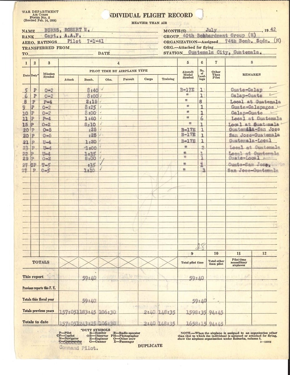
July 1942 — Individual Flight Record (Form 5), Guatemala City. The July 5th and 6th entries show the outbound and return legs of a Galapagos patrol: 8 hours 40 minutes out, 8 hours back. The two-day pattern matches exactly: fly out, sleep over, return at dawn.
The outbound legs ("Gute-Galap" / "Gute-Galapagos") and return legs ("Galap-Cunte") pair up across consecutive days — the Form 5 route abbreviations trace the exact two-day overnight pattern Bob described. Each leg runs 8–8:40 hours, bracketing his "about 7-8 hours" estimate closely. Earlier confirmed entries appear in May: May 2 and May 7 each show "Guatemala-Galapagos-Guatemala" at 8:15 and 8:00 hours. By July Bob was flying the route twice a week. The single landing on each leg reflects the long over-ocean transit with no intermediate stops.
View all Canal Zone & Guatemala flight records →